- Home
- News
- What’s On
- Activities for Children
- Arts & Crafts
- Autos and Bikes
- Business events
- Car Boot & Auctions
- Charity events
- Churches & Religious
- Comedy
- Dance
- Days out & Local interest
- Education
- Exhibition
- Film
- Gardening & Horticulture
- Health
- Markets & Fairs
- Music
- Nature & Environment
- Spiritual
- Sport
- Talks and Discussions
- Theatre and Drama
- Business
- Local Information
- Jobs
- Deaths
- Charity events
- Contact Us
Peak Park pioneers A.I.
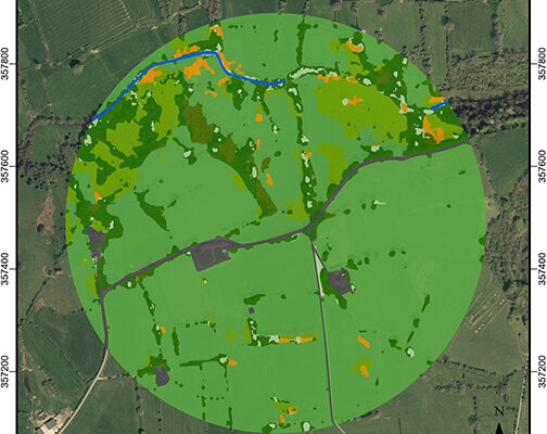
The Peak District National Park is pioneering the use of Artificial Intelligence to monitor the landscape.
The Peak District National Park has partnered with Cranfield University and the Alan Turing Institute to pioneer the use of Artificial Intelligence (AI) to produce highly detailed land cover maps from aerial photographs of habitats and species.
AI automates and vastly speeds up the process of producing the maps; a process which previously took years for a team to perform, now only takes one day for a computer.
Using high-resolution aerial photography from BlueSky International, National Park staff have developed a new version of the deep-learning network that automatically classifies the landscape into different land cover classes for the AI to learn from.
This method enabled AI to create a land cover map for the National Park in more detail and with higher resolution than ever before, and significantly, in just a fraction of the time it would take to produce manually.
Land cover maps are essential tools used by scientists, planners, policy-makers and land managers for measuring and monitoring the state of natural landscapes. The quality and effectiveness of these maps in landscape ecology, climate change mitigation and conservation work depends on their resolution and accuracy.
The new approach can be used to detect a wide range of habitats from aerial image data: from those with a broad species mix and mosaics to single species, and is particularly useful where important habitats are small and mixed. It helps people observe species and habitats over an area to gain understanding of their spread and measure progress, for example, against nature recovery targets.
Monitoring landscape change in a repeatable and accurate manner has historically been expensive and time-consuming. The last detailed land cover census for National Parks was carried out over 30 years ago (in 1991) by the Countryside Commission. At that time, aerial photography from the early 1970s and late 1980s was interpreted by hand, and it took a research team nearly 4 years to map all UK National Parks.
David Alexander, research and data analyst at the Peak District National Park, said: “Repeating the 1991 survey was not practical or affordable, so we set out to develop an easily repeatable, accurate and cost-effective way of monitoring land cover across the Peak District’s dynamic and varied landscapes.
“We partnered with Cranfield University and The Alan Turing Institute to draw on current AI research using visible colour, aerial imagery from BlueSky International.”
Land cover was classified from the BlueSky photography using Convolutional Neural Networks, a deep-learning AI method that excels in labelling natural photography.
Thijs van der Plas, from The Alan Turing Institute, said: “Using this methodology, broad, high-level classes such as moorland, woodland or grasslands, were predicted with 95 per cent accuracy, equivalent to human error rates. Then, in a second pass of the networks, low-level, detailed classes such as heather moor or deciduous woodland, were predicted with 72 to 92 per cent accuracy.
“The AI predictions were merged with topographic maps from Ordnance Survey to create a complete land cover map of the Peak District.”
Dr Daniel Simms, senior lecturer in remote sensing at Cranfield University, said: “AI, in combination with earth observation information such as the BlueSky aerial photography provides significant advantages over direct measurement and other digital methods, such as ground-based photography and earth observation.
“Predictions are fast, as no field visits are required for data collection, and continuous over the landscape compared to time-consuming and resource-intensive surveys of individual habitats, or sensor networks at fixed locations.
“The methods developed for this project can have a much wider applications in monitoring biodiversity across the UK Protected Landscapes and inform and deliver on the government’s pledge to protect 30 per cent of the UK’s land and sea by 2030.”
Ralph Coleman, chief commercial officer at BlueSky, said: “By making our nationwide cover of the highest resolution, most up-to-date aerial data available to projects such as these through the Aerial Photography for Great Britain contract, we are helping to drive innovation across a number of sectors.
“This pioneering use of AI for landscape monitoring clearly achieves efficiencies and savings which can be applied to tackling issues such loss of biodiversity and habitat fragmentation; and it demonstrates a working model that can be applied to other scenarios.”
Two reports about the pioneering work have been published online, available for free at:
· The Alan Turing Institute https://www.turing.ac.uk/news/publications/data-study-group-final-report-peak-district-national-park-authority
· The Multidisciplinary Publishing Institute https://www.mdpi.com/2072-4292/15/22/5277
You must be logged in to post a comment Login